Our survey services lay the groundwork for project excellence, capturing and validating preliminary survey and as-built construction data from beginning to end.
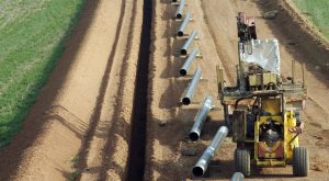
Surveying is a critical component to worry-free, on time and on budget project delivery. With a complete array of pipeline survey services, EnSiteUSA provides scalable and cost-effective solutions tailored to your unique needs and project requirements. Our professional land surveyors (PLS) are licensed and registered in over 30 states and are equipped with the latest in survey and mapping technology.
Solid Data Makes the Difference
As-built documentation is more important than ever. Our surveyors will capture and validate construction data to ensure design integrity and adherence to industry standards. Utilizing our proprietary applications, ToolShed and SurvPipe, construction data, including critical material information, design vs as-built compliance checks and progress reports are available within 24 hours via our EPIC (EnSiteUSA Project Information Center) portal. Final deliverables can be provided in a wide variety of formats.
Pipeline and Land Surveying Capabilities:
Control Surveys (Network, Project and Photogrammetry Control)
Route Selection and Reconnaissance Surveys
Route Surveys
Facility Site Surveys
Land Surveys
Acquisition Exhibits
Topographic Surveys
Crossing Profile Survey for Permitting
3D Laser Scanning
Subsurface Utility Engineering (SUE) Surveys
Boundary Surveys and Land Acquisition Exhibits
ALTA-ACSM Land Title Surveys
Construction Staking and Facilities Layout
As-built Surveys incorporating ToolShed (pipe tally, weld mapping, in-ditch and post-construction data collection)
Design vs As-built compliance utilizing SurvPipe
Above Ground Marker AGM Surveys and Inline Inspection Support